Hello/Bonjour/Guten Tag

Welcome to my portfolio page.
Here you will find some of my latest geospatial work.
If you like what you see, get in touch!

I developed a passion for GIS and remote sensing while completing my BSc at UBC. Since then, I've done geospatial work across various industries, from ecological landscape classification in Yukon to telecommunications infrastructure planning in Germany. I'm currently completing BCIT's Advanced Diploma in GIS while working as a Senior GIS Technician at NOAH Intelligence, a Toronto-based startup where I build geospatial data pipelines for property-level flood risk modeling.

Skills

Core competencies developed over multiple industries.

  • ArcGIS Pro & ArcGIS Online, QGIS
  • Spatial Analysis
  • Cartographic Design
  • Remote Sensing
  • Python, ArcPy, PyQGIS, SQL
  • Trilingual: EN / FR / DE

My Story

Yukon

Originally from Quebec, my family moved to Whitehorse, Yukon when I was eight. Growing up in the North gave me an early appreciation for the outdoors and environmental issues, eventually leading me to a BSc in Natural Resources Conservation at UBC. It was there that I discovered GIS, a field that immediately resonated with my love of technical problem-solving and big-picture thinking. I was fortunate to gain hands-on experience at UBC's Integrated Remote Sensing Studio, supporting graduate research with remote sensing and GIS analysis.

After graduation, I worked for the Yukon Government as a GIS technician on the Ecological Landscape Classification program, combining summer fieldwork with ecological map production.

Munich

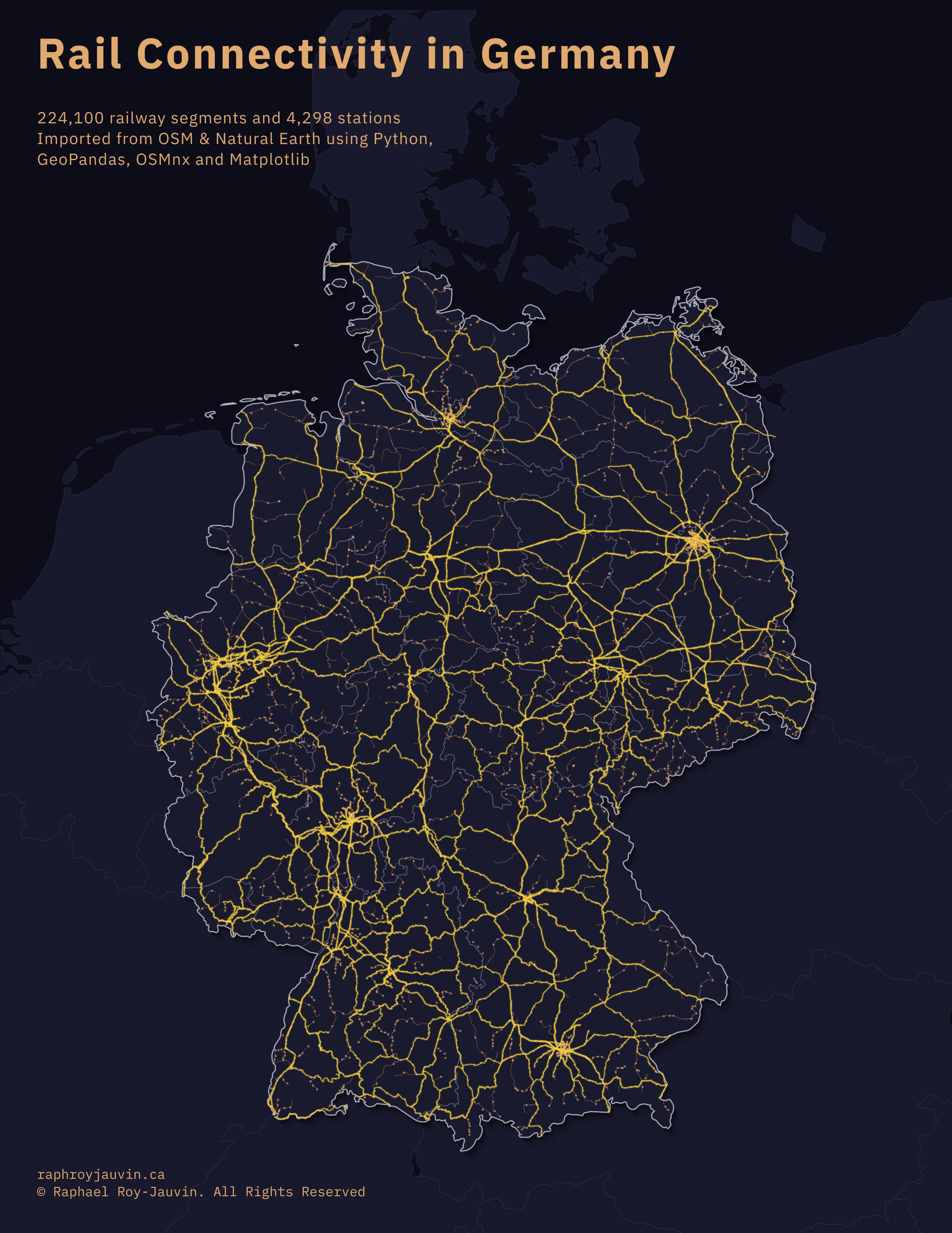
Wanting to experience life abroad, I then moved to Munich, Germany, where I worked as a GIS planner for MRK Media AG, supporting the rollout of fiber-optic infrastructure across southern Germany.

Upon returning to Canada, I sought something different: a professional challenge that would test my resilience and offer immediate, tangible impact. This drew me to emergency services. What started as a departure from desk work became a career with BC Emergency Health Services, first as a paramedic and eventually as a dispatch supervisor.

New York

EMS gave me meaningful work, resilience, and leadership skills, but it also shifted my perspective. Responding to emergencies across diverse communities gave me a firsthand understanding of how infrastructure and environmental risk shape people's lives. Having accomplished what I set out to do in emergency services, it was time to reconnect with GIS, this time applying those skills toward understanding and mitigating real-world risk through geospatial technology. I'm currently completing BCIT's Advanced Diploma in GIS while working at NOAH Intelligence, where I prepare the geospatial datasets that feed into property-level flood risk models. I couldn't be more excited about what's ahead.

Resume

Education

Advanced Diploma in Geographic Information Systems

British Columbia Institute of Technology | Online | Expected 2026
Coursework: Fundamentals of GIS, Mapping, GIS Programming, CAD for GIS, Database Systems, Remote Sensing, Spatial Analysis

Bachelor of Science — Natural Resources Conservation

University of British Columbia | Vancouver, BC | 2008–2012
Dean's Honour Roll
Coursework: Land Use Planning, Basic and Advanced GIS, Remote Sensing, Cartography

GIS Work Experience

Senior GIS Technician | NOAH Intelligence Inc. | February 2026 – Present

Prepare and validate geospatial datasets for property-level flood risk modeling powered by coupled 1D/2D hydraulic simulation. Develop automated processing workflows in QGIS and ArcPy to ensure data integrity across multiple municipal study areas. Designed and deployed a custom Python tool that resolved 98%+ of missing attribute values across municipal infrastructure networks, eliminating weeks of manual data derivation. Authored proposals for GIS data management and pipeline optimization to improve team efficiency and support scaling.

Telecommunications GIS Planner | MRK Media AG | Munich, Germany | 2016–2017

Designed fiber optic infrastructure plans using GIS-based tools. Created cartographic products and technical documentation for engineering teams and planning approvals.

Landscape Classification GIS Specialist | Yukon Government | 2012–2013

Maintained geodatabases and created thematic ecological maps. Conducted spatial analysis for landscape classification. Participated in ecological fieldwork and data collection.

Remote Sensing and GIS Assistant | University of British Columbia | 2008–2012

Supported graduate research in remote sensing. Co-authored peer-reviewed study on climate-induced tree species range shifts. Produced habitat extent maps under multiple climate scenarios.

Other Work Experience

BC Emergency Health Services | Victoria, BC | 2017–Present

Dispatch Supervisor (2024–Present) | Emergency Medical Dispatcher (2018–2024) | Paramedic (2017–2018)
Operational leadership for 12-person dispatch team. Coordinate multi-agency responses across Vancouver Island using GIS-enabled dispatch software and real-time situational analysis. As a paramedic, responded to medical emergencies and provided patient assessment, treatment, and transport.

Additional Achievements

C1 German Language Certification
Goethe Institute | Montreal, QC | 2025

Primary Care Paramedic Certification
Justice Institute of British Columbia | Victoria, BC | 2016

Yukon Commissioner's Award for Bravery
Whitehorse, Yukon | 2013
Recognized for providing aid during a remote helicopter incident while significantly injured.

Recent Work

A selection of my recent GIS work and projects.

Geospatial Data Pipeline for Flood Risk Modeling

Geospatial Data Pipeline for Property-Level Flood Risk Modeling

At NOAH Intelligence, I prepare and validate municipal geospatial datasets for use in coupled 1D/2D hydraulic flood simulations. The pipeline involves spatial processing and manual geometry repair in QGIS, automated attribute gap-filling via custom ArcPy script tools, and iterative validation to produce simulation-ready outputs. A custom Python tool I built resolves 98%+ of missing attribute values across municipal infrastructure networks, eliminating weeks of manual derivation.

Ottawa Montreal Rail Analysis

Ottawa-Montreal ALTO High-Speed Rail Corridor Analysis

A spatial analysis of Canada's first announced high-speed rail segment. Evaluated population catchment areas, land use composition, and station accessibility across the 200km Ottawa-Montreal corridor using Census data, AAFC land cover, and OpenStreetMap sources.

GVRD Network Analysis

Greater Vancouver Ambulance Response Times: A Network Analysis

A network-based analysis evaluating ambulance response times and population exposure relative to provincial emergency response benchmarks under different traffic scenarios. By combining a GIS network analysis with my emergency services domain knowledge, I modeled EMS coverage across Metro Vancouver, quantifying how many residents fall within (and beyond) critical response time thresholds.

Victoria LRT Suitability Analysis

Victoria LRT Feasibility Analysis

An exploration of potential light rail routes for the Capital Regional District. Used weighted overlay analysis combining population density, transit stop density, proximity to the E&N rail corridor, and distance from activity centres to identify high-need areas and propose two route options.

Rail Connectivity in Germany

Rail Connectivity in Germany

Built a high-resolution map of Germany’s rail network by extracting OpenStreetMap data with Python and rendering it in Matplotlib, then exported the cleaned layers to a GeoPackage for easy use in ArcGIS Pro.

Get In Touch

Interested in working together or have a question? Feel free to reach out.